There are long and short routes, challenging and suitable for every pair of feet:
camino frances, long and extremely popular
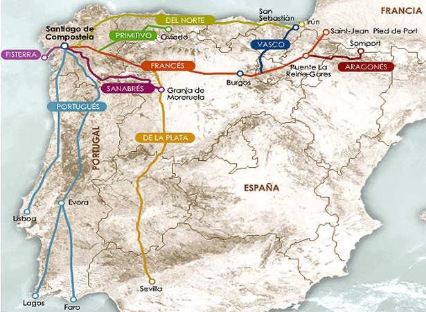
It is the most traditional route, attracting more people than all the other caminos combined: the Camino Francés (French Path) begins in St-Jean-Pied-de-Port, on the French side of the Pyrenees, and continues for about 770 km across northern Spain to Santiago de Compostela, Temperatures are generally muggy in summer and cold in winter. Some stretches are unpaved, others wind along busy paved roads.
intermediate points where to start,I recommend senpre to start from the beginning, are leon,burgos ,o’cebreiro oppre sarria last 100 km.
Camino Portugués
is the second busiest route and requires about 3 1/2 weeks of walking to complete the more than 600 km between Lisbon and Santiago. Many decide to save some km by walking from alternative starting points, such as charming Porto in northern Portugal (about 240 km from Santiago, about 10 days) and Tui, on the outskirts of Spain (115 km). The Portuguese Way is within the reach of any averagely fit person: there are few hilly climbs, but much of the walk is on paved surfaces (roads, sidewalks, cobblestones) so budget for sore feet.
Camino del Norte
stretches parallel to the northern Spanish coast for more than 600 km from Irún, on the French border, to Ribadeo, then advances inland through Galicia to Santiago de Compostela for another 300 km or so
You will touch major cities such as San Sebastián, Bilbao, Santander, Gijón, and delightful seaside towns such as Comillas, Ribadesella, and Luarca. The Camino del Norte includes some fairly long stretches of walking to be done by road. The first hills to be climbed in the Basque Country provide the most unforgettable views.
There is to say that it is nicknamed camino rompi piernas: there are continuous ups and downs,you go up and down all the time but the landscapes with its coves are wonderful such as the playa of the cathedrals in ribadeo…ps you can also go down on the primitive towards vilaviciosa and continue on that.
the norte joins the camino frances at arzua
The Camino Primitivo,
about 320 km long, retraces the footsteps of the first pilgrim to walk to the tomb of St. James: King Alfonso II of Asturias, who set out from Oviedo in the year 829 and with his court was the first pilgrim to Santiago
It is considered one of the most difficult caminos because of the elevation changes to be faced in the early ones (it can become impassable in the snowy winter months,but in winter it is wonderful) but the ups and downs only enhance the beauty of the landscapes and the route is still suitable for any fit walker.It is a path that has an unspoiled naturalness ,and wonderful mountain passes with its hospitales stage of about 27 km in the mountains without finding a soul…horses in the wild for sure.
it enters lugo,where there is a wonderful roman wall that is a world heritage site…it connects on the french to melide
ps for those who would like there is the ancient tradition that says:
whoever goes to santiago without passing through the savior,honors the sevo and not the lord….cioe there is a camino de salvador that starts from leon heading north to oviedo,where there is the holy room and it is 125 km of mountains and wonderful solitude,once you get to oviedo you can request the salvadorena for having done this camino
camino ingles
it starts from ferrol,in galicia in the north,and with about 125 km you get to santiago in 4/5 days
camino used in the middle ages by the English who landed on the coast of galicia to get to santiago
has no major relief and is within the reach of all,it has few albergues so in times of full affluence there is difficulty in finding room
ps you could also make an extra stop to stop in’ coruna.
via de la plata
a very long path of about 1000 km that starts in cadiz and joins to towards granja de morieuela on the camino sanabres and head towards santiago or continue to astorga on the french camino
a very lonely but intensely scenic path with its Roman cities
not to be recommended in the summer because as the Spaniards say…you get melted by the high temperatures of extremadura
fireplace finistrerre muxia
The name Finisterre means “end of the world”: at Cape Finisterre, a cape lined with cliffs on which a lighthouse towers, there is indeed an apocalyptic atmosphere. In Muxía, you will find the 18th-century church built on a spot where the Virgin Mary is said to have appeared aboard a stone boat.
it’s about 90 km to get to finisterre,where you can request the finisterrana at the tourist office if you still have time you can do the 31 km stage that connects it to muxia with its fascinating church suspended over the ocean and its magical atmosphere that lives in here places,and also here you can request the muxiana in any albergues
camino mozarabico
The Mozarabic Way is a 200-kilometer stretch of the Camino Mozarabico that starts in Almería or Málaga and goes all the way to Mérida where it connects with the via de la plata-a name given to the group of paths to Santiago de Compostela that in the Middle Ages were traveled by pilgrims from Andalusian towns belonging to the ancient Muslim territory of al-Àndalus.
Another of the characteristics of the Mozarabe Way (between Granada and Cordoba) is the considerable distance between the cities, and it is worthwhile to stock up on water as springs do not abound and water does not always flow from some.
We need to avoid the summer months to undertake this walk as temperatures are very high in summer and can easily reach 40 degrees official temperature (in the shade).Currently, the Mozarabic Way is not very busy and signage has recently been implemented.
aragonese camino
The Aragonese Way takes its name from the region it crossed before entering Navarre. A pilgrimage route traveled in ancient times by those, like the Italians, who came from the south of France along the Via Tolosana and crossed the Pyrenees at the Somport Pass – the border between Spain and France – and still the starting point of the Aragonese Way. It is 165 km long, which is generally covered in six stages, in mostly rural and charming areas. It is an entry variant to the French Way, with which it joins near Puente la Reina and more specifically in Obanos.
The history of this road dates back to the 11th century when the first kings of Aragon decided to improve the communication network of their territories, reconstructing roads that were still in use from Roman times and building new ones, as well as the renovation of bridges and housing intended for the most important routes in Hispanic territory. Today, it is one of the loneliest routes among the Ways of St. James also because it runs close to high altitude places, there is great snowfall from November to almost May, which makes it more difficult to make a good pilgrimage. Also, we should remember that the route starts in the Pyrenees and then runs through forests and small towns with great charm.
camino olvidado
During the 9th and 12th centuries, Spanish territory was in the midst of reconquering lands occupied by Muslim troops.
– The constant battles that were taking place conveyed great anxiety to the pilgrims in the area, who decided to abandon the interior highland route and make the pilgrimage further north on the peninsula.
Even in the north, pilgrims found a coastal route too complicated, which led them to seek an alternative.
They were in the middle of a crossroads, to the north a complicated route along the coast and further south constant attacks by Muslim troops, so the alternative there was left is what is now known as the Camino Olvidado.
This route made it possible to cross the Pyrenean mountain range and continue into the lower mountain area, following a slightly complicated route.
When the flat areas of the northern plateau fell on the side of the Reconquista, the Kings of Navarre and Castile and Leon brought greater security to the French Way, , as well as the fact that it has a simpler route, caused the Camino Olvidado to fall into disuse, hence its name.
Currently, there are dive in rse associations that are trying to recover the use of this alternative route.
Up to such a point is the rescue initiative of this Way that a connection point with the French Way has been made at the height of Bárcena.
From Bilbao to Villafranca del Bierzo and then, via the French Way or, from Ponferrada by the Winter Walk, to the destination of Santiago de Compostela. This route of the Camino de Santiago is divided into 18 stages.
camino de invierno
The Winter Path is the natural entrance to Galicia from the meseta, an access already used by the Romans. It is thought that it could have been an alternative during winter to the hard climb to the snow-capped peaks of O Cebreiro
During a route of just over 200 km it crosses the four provinces of Galicia and historic comarcas, full of personality and charm such as those of Valdeorras, ribeira sacra or Deza. The Winter Walk is the natural entrance to Galicia from the meseta, an access already used by the Romans. It is thought to have originated as an alternative, in the winter period, to the harsh ascent to the snow-capped peaks of O Cebreiro, from where the French Way enters Galicia, and also to avoid the frequent overflowing of rivers in the Valcárcel valley.
It begins at Ponferrada -prelude to the Galician lands, in the territorial district of Bierzo-. Here the pilgrim veers left, instead of continuing straight along the French Way. The Winter Path practically follows the Sil, a river rich in water, in the area of Valdeorras in the province of Orense. It proceeds, then, in the south of the province of lugo, continuing in the territorial district of Deza (Pontevedra), until it reaches santiago . In total, just under 250 kilometers for the four provinces of Galicia.